Jeffrey D. Phillips
Retired Geophysicist
United States Geological Survey
Biography
EDUCATION:
A.B. (1970), University of California, Berkeley
(Geology)
M.S. (1973), Stanford University (Geophysics)
Ph.D. (1975),
Stanford University (Geophysics)
EMPLOYMENT:
1973: U.S. Geological Survey (Menlo Park, CA, and Beaufort Sea, AK)
1975-1991: U.S. Geological Survey (Reston, VA):
1980-1986: Branch Representative,
Eastern Region, Branch of Geophysics
1991-2025: U.S. Geological Survey (Denver, CO)
1991-2014: Research Geophysicist
2014-2025: Scientist Emeritus
Jeff Phillips is retired from the Geology, Geophysics, and Geochemistry Science Center
in Denver, Colorado. He
developed and maintained the USGS
potential-field geophysical software package for the PC, a
public-domain resource for the geophysical community.
His research focused on potential-field theory and
its application to geologic problems, including water, mineral, and
energy resources.
Selected Publications
Shah, A.K., Taylor, R.D., Walsh, G.J., and Phillips, J.D.,
2021, Integrated geophysical imaging of rare earth element-bearing iron
oxide-apatite deposits in the Eastern Adirondack Highlands, New York: Geophysics, Volume 86, Issue 1, January-February 2021, Pages B37-B54. [Link]
Shah, A.K., Phillips, J.D.,
Lewis, K.A., Stanley, R.G., Haeussler, P.J., and Potter, C.J.,
2020, Three-dimensional shape and structure of the Susitna basin,
south‑central Alaska, from geophysical data: Geosphere, Volume 16. [Link]
Phillips, J.D., and McCafferty,
A.E., 2019, Crustal Architecture Beneath the Southern Midcontinent
(USA) -- Data Grids and 3D Geophysical Models: U.S. Geological Survey
Data Release. [Link]
McCafferty, A.E., Phillips, J.D.,
Hofstra, Albert, and Day, Warren, 2019, Crustal Architecture Beneath
the Southern Midcontinent (USA) and Controls on Mesoproterozoic
Iron-Oxide Mineralization from 3D Geophysical Models: Ore Geology Reviews, Volume 111, August 2019. [Link]
Stanley, R.G., Potter, C.J., Lewis, K.A., Lillis, P.G., Shah, A.K., Haeussler, P.J., Phillips, J.D.,
Valin, Z.C., Schenk, C.J., Klett, T.R., Brownfield, M.E., Drake, R.M.,
Finn, T.M., Haines, S., Higley, D.K., Houseknecht, D.W., Le, P.A.,
Marra, K.R., Mercier, T.J., Leathers-Miller, H.M., Paxton, S.T.,
Pearson, O.N., Tennyson, M.E., Woodall, C.A., and Zyrianova, M.V.,
2018, Assessment of undiscovered oil and gas resources of the Susitna
Basin, southern Alaska, 2017: U.S. Geological Survey Fact Sheet
2018–3017, 2 p. [Link]
Phillips, J.D.,
2018, PDEPTH—A computer program for the geophysical interpretation of
magnetic and gravity profiles through Fourier filtering, source-depth
analysis, and forward modeling: U.S. Geological Survey Techniques and
Methods, book 7, chap. C17, 23 p. [Link]
See updated software at [ftp jphil55.ddns.net].
McCafferty, A.E., Phillips, J.D., and Ayuso, R.A.,
2017, Crustal architecture beneath the southeast Missouri (USA)
Mesoproterozoic Iron-Oxide province from geophysical models:
Proceedings of the 14th SGA Biennial Meeting, 20-23 August 2017, Quebec
City, Canada: p. 871-874. Hammarstrom, J.M., Mihalasky, M.J., Ludington, Steve, Phillips, J.D.,
Berger, B.R., Denning, P.D., Dicken, C.L., Mars, J.C., Zientek, M.L.,
Herrington, R.J., and Seltmann, Reimar, 2017, Undiscovered porphyry
copper resources in the Urals—A probabilistic mineral resource
assessment: Ore Geology Reviews, Volume 85, May 2017, Pages 181-203. [Link]
McCafferty, A.E., Phillips, J.D., and Driscoll,
R.L., 2016, Magnetic and Gravity Gradiometry Framework for
Mesoproterozoic Iron Oxide-Apatite and Iron Oxide-Copper-Gold Deposits,
Southeast Missouri: Economic Geology, v.111, no.8, p.1859-1882.
Smith, K.S., Phillips, J.D., McCafferty, A.E., and
Clark, R.N., eds., 2016, Developing integrated methods to address
complex resource and environmental issues: U.S. Geological Survey Circular 1413, 160 p. [Link]
Phillips, J.D., 2016, Potential-field software, in
Smith, K.S., Phillips, J.D., McCafferty, A.E., and Clark, R.N., eds.,
2016, Developing integrated methods to address complex resource and
environmental issues: U.S. Geological Survey Circular 1413, p. 35-37. [Link]
Phillips, J.D., and Berger, B.R., 2016, Geophysical support for global mineral resource assessments, in
Smith, K.S., Phillips, J.D., McCafferty, A.E., and Clark, R.N., eds.,
2016, Developing integrated methods to address complex resource and
environmental issues: U.S. Geological Survey Circular 1413, p. 52-53. [Link]
Phillips, J.D., and Stanley, R.G., 2016,
Three-dimensional magnetic property model characterizing the Mesozoic
section of the Cook Inlet Basin, south-central Alaska, in
Smith, K.S., Phillips, J.D., McCafferty, A.E., and Clark, R.N., eds.,
2016, Developing integrated methods to address complex resource and
environmental issues: U.S. Geological Survey Circular 1413, p. 57-59. [Link]
Grauch, V.J.S., and Phillips, J.D., 2016, Providing
a subsurface framework for regional groundwater models of alluvial
basins-example from the southern Española Basin, north-central New
Mexico, in Smith, K.S., Phillips, J.D., McCafferty, A.E., and
Clark, R.N., eds., 2016, Developing integrated methods to address
complex resource and environmental issues: U.S. Geological Survey Circular 1413, p. 113-115. [Link]
Phillips, J.D., and Burton, B.L., 2016,
Ground-based magnetic survey for a basalt aquifer in Frenchman Flat,
Nevada National Security Site and Nevada Test and Training Range,
Nevada, in Smith, K.S., Phillips, J.D., McCafferty, A.E., and
Clark, R.N., eds., 2016, Developing integrated methods to address
complex resource and environmental issues: U.S. Geological Survey Circular 1413, p. 129-131. [Link]
Phillips, J.D., and Asch, Theodore, 2016, Estimating bedrock depth using constrained gravity inversion, Tooele Army Depot, Utah, in
Smith, K.S., Phillips, J.D., McCafferty, A.E., and Clark, R.N., eds.,
2016, Developing integrated methods to address complex resource and
environmental issues: U.S. Geological Survey Circular 1413, p. 131-133. [Link]
Smith, D.V., Bracken, R.E., Hutton, S.R., and Phillips, J.D., 2016, Development of a ground-based tensor magnetic gradiometer system, in
Smith, K.S., Phillips, J.D., McCafferty, A.E., and Clark, R.N., eds.,
2016, Developing integrated methods to address complex resource and
environmental issues: U.S. Geological Survey Circular 1413, p. 138-140. [Link]
Phillips, J.D., 2015, 11.12 – Tools and Techniques: Gravitational Method, in Treatise on Geophysics (Second Edition), edited by Gerald Schubert, Elsevier, Oxford, 2015, Volume 11: Resources in the Near-Surface Earth, p. 393–418, ISBN 9780444538031 [Link]
Phillips, J.D., and Simpson, R.W., 2015, Sharpening the boundaries - 3D terracing applied to physical property inversions: Society of Exploration Geophysicists 2015 Technical Program Expanded Abstracts, p. 1536-1540. [Link]
Smith, D.V., Phillips, J.D., and Hutton, S.R., 2014, Active tensor magnetic gradiometer system final report for Project MM-1514: U.S. Geological Survey Open-File Report 2013-1228, 39 p. [Link]
DeCastro, D.L., Fuck, R.A., Phillips, J.D.,
Vidottib, R.M., Bezerraa, F.H.R., and Dantas, E.L., 2014, Crustal
structure beneath the Paleozoic Parnaíba Basin revealed by airborne
gravity and magnetic data, Brazil: Tectonophysics, v.614, p.128-145.
Berger, B.R., Mars, J.C., Denning, P.D., Phillips, J.D.,
Hammarstrom, J.M., Zientek, M.L, Dicken, C.L., and Drew, L.J., with
contributions from Alexeiev, D., Seltmann, R., and Herrington, R.J.,
2014, Porphyry copper assessment of western Central Asia: U.S.
Geological Survey Scientific Investigations Report 2010–5090–N, 219 p.,
8 plates, and spatial data. [Link]
Phillips, J.D., 2014, Using vertical Fourier
transforms to invert potential-field data to magnetization or density
models in the presence of topography: Society of Exploration Geophysicists, Expanded Abstracts with Author's Biographies, 2014 Technical Program, p.1339-1343. [Link]
Phillips, J.D., Burton, B.L., Curry-Elrod, Erika,
and Drellack, Sigmund, 2014, A ground-based magnetic survey of
Frenchman Flat, Nevada National Security Site and Nevada Test and
Training Range, Nevada—Data release and preliminary interpretation: U.S. Geological Survey Open-File Report 2014–1187, 144 p., 1 pl. [Link]
Bedrosian, P.A, Burton, B.L., Powers, M.H., Minsley, B., Phillips, J., Hunter, L.E., 2012, Geophysical investigations of geology and structure at the Martis Creek Dam, Truckee, CA, J. Applied Geophysics, v. 77, p. 7-20.
Abraham, J.D., Bedrosian, P.A., Asch, T.H., Ball, L.B., Cannia, J.C., Phillips, J.D.,
and Lackey, Susan, 2012, Evaluation of geophysical techniques for the
detection of paleochannels in the Oakland area of eastern Nebraska as
part of the Eastern Nebraska Water Resource Assessment: U.S. Geological
Survey Scientific Investigations Report 2011–5228, 40 p. [Link]
Phillips, J.D., 2010, Estimating structural dip from gravity and magnetic profile data: Society of Exploration Geophysicists, 2010 Technical Program Expanded Abstracts, 5p. [Link]
Grauch, V.J.S., Phillips, J.D., Koning, D.J.,
Johnson, P.S., and Bankey, Viki, 2009, Geophysical interpretations of
the southern Española basin, New Mexico, that contribute to
understanding its hydrogeologic framework: U.S. Geological Survey Professional Paper 1761, 88 p. [Link]
Ravat, D., Finn, C., Hill, P., Kucks, R., Phillips, J.,
Blakely, R., Bouligand, C., Sabaka, T., Elshayat, A., Aref, A., and
Elawadi, E., 2009, A preliminary, full spectrum, magnetic anomaly grid
of the United States with improved long wavelengths for studying
continental dynamics--A website for distribution of data: U.S. Geological Survey Open-File Report 2009–1258, 2 p. [Link]
Phillips, J.D., Hansen, R.O., and Blakely, R.J., 2007, The use of curvature in potential-field interpretation: Exploration Geophysics, v.38, p.111-119. [Link]
Phillips, J.D., Nabighian, M.N., Smith, D.V., and
Li, Yaoguo, 2007, Estimating locations and total magnetization vectors
of compact magnetic sources from scalar, vector, or tensor magnetic
measurements through combined Helbig and Euler analysis: Society of Exploration Geophysicists, Seventy-Seventh Annual Meeting, San Antonio, Texas, Sept. 23-28, 2007, 5 pp. [Link]
Phillips, J.D., 2007, Geosoft eXecutables (GX’s)
Developed by the U.S. Geological Survey, Version 2.0, with Notes on GX
Development from Fortran Code: U.S. Geological Survey Open-File Report 2007-1355, 111 p. [Link]
Saltus, R. W.; Phillips, J. D.; Stanley, R. G.;
Till, A.; Morin, R. L.,2007, Geophysical Characterization of
Pre-Cenozoic Basement for Hydrocarbon Assessment, Yukon Flats, Alaska: U.S. Geological Survey Open-File Report 2007-1208, 1 plate. [Link]
Phillips, J.D., 2006, The role of negative structural indices in magnetic interpretation - lessons from the Bishop model: Society of Exploration Geophysicists, 2006 Workshop W-5 The Bishop Model: Investigations into the Use and Abuse of Test Models [Link]
Phillips, J.D., 2005, Can we estimate total magnetization directions from aeromagnetic data using Helbig's integrals?: Earth, Planets and Space, v.57, no.8, p.681-689. [Link]
Phillips, J.D., and V.J.S. Grauch, 2004, Thickness
of Santa Fe Group sedimentary rocks in the southern Española basin, New
Mexico, as estimated from aeromagnetic data: U.S. Geological Survey Open-File Report 2004-1354. [Link]
Phillips, J.D., Duval, J.S., and Saltus, R.W.,
2003, Geosoft executables (GXs) developed by the U.S. Geological
Survey, version 1.0, with a viewgraph tutorial on GX development: U.S. Geological Survey Open-File Report 03-010, 21p. [Link]
Phillips, J.D., 2002, Two-step processing for 3D
magnetic source locations and structural indices using extended Euler
or analytic signal methods: Society of Exploration Geophysicists, 2002 Technical Program Expanded Abstracts, 4p. [Link]
Phillips, J.D., 2002, Processing and Interpretation
of Aeromagnetic Data for the Santa Cruz Basin-Patagonia Mountains Area,
South-Central Arizona: U.S. Geological Survey Open-File Report 02-98. [Link]
North American Magnetic Anomaly Group (NAMAG), Phillips, J.D.,
and Ravat, D.K.A., 2002, Digital data grids for the magnetic anomaly
map of North America: U.S. Geological Survey Open-File Report 02-0414. [Link]
Phillips, J.D., 2001, Tools and techniques for the application of high-resolution aeromagnetic data to engineering problems: Proceedings, SAGEEP 2001, CD-ROM, 22p. [Link]
Phillips, J.D., 2001, Designing matched bandpass
and azimuthal filters for the separation of potential-field anomalies
by source region and source type: Australian Society of Exploration Geophysicists, 15th Geophysical Conference and Exhibition, Expanded Abstracts CD-ROM, 4p. [Link]
Phillips, J.D., and Grauch, V.J.S., 2001, Some
current research on the processing and interpretation of
potential-field data at the U.S. Geological Survey: Proceedings of the workshop on future directions in the analysis of potential-field data, August 18, 2001, Perth, Australia. 4p. [Link]
Phillips, J.D., 2000, Locating magnetic contacts: a comparison of the horizontal gradient, analytic signal, and local wavenumber methods: Society of Exploration Geophysicists, Expanded Abstracts with Biographies, 2000 Technical Program, v.1, p.402-405. [Link]
Phillips, J.D., Saltus, R.W., and Reynolds, R.L.,
1998, Sources of magnetic anomalies over a sedimentary basin -
preliminary results from the coastal plain of the Arctic National
Wildlife Refuge, Alaska, in Gibson, R.I., and Millegan, P.S., eds., Geologic Applications of Gravity and Magnetics: Case Histories: Society of Exploration Geophysicists and American Association of Petroleum Geologists, p.130-134.[Link]
Phillips, J.D., 1998, An interpretation of
proprietary aeromagnetic data over the northern Arctic National
Wildlife Refuge and adjacent areas, northeastern Alaska, in ANWR Assessment Team, Resource Potential of the 1002 Area, Arctic National Wildlife Refuge, Alaska: U.S. Geological Survey Open-File Report 98-34 (CD-ROM), 19p. [Link]
Phillips, J.D., 1997, Potential-field geophysical software for the PC, version 2.2: U.S. Geological Survey Open-File Report 97-725, 34p. [Link]
Software at [ftp jphil55.ddns.net]
Phillips, J.D., 1996, Potential-field continuation: past practice vs. modern methods: Society of Exploration Geophysicists, Expanded Abstracts with Bibliographies, 1996 Technical Program, v.2, p.1411-1414.[Link]
Phillips, J.D., and Fitterman, D.V., 1995, Environmental geophysics: Reviews of Geophysics, Supplement, U.S. National Report to International Union of Geodesy and Geophysics 1991-1994, July 1995, p.185-193.
Phillips, J.D., 1995, Aeromagnetic investigations of hazardous waste sites: U.S. Geological Survey Factsheet FS-077-95, 2 pages. [Link]
Phillips, J.D., 1995, Magnetic surveys for locating abandoned wells: U.S. Geological Survey Factsheet FS-0163-95, 2 pages. [Link]
Phillips, J.D., Duval, J.S., and Ambroziak, R.A.,
1993, National geophysical data grids; gamma-ray, gravity, magnetic,
and topographic data for the conterminous United States: U.S. Geological Survey Digital Data Series DDS-9, CD-ROM [no longer available for purchase]. Data files at [ftp jphil55.ddns.net].
Phillips, J.D., Reynolds, R.L., and Frey, Herbert, 1991, Crustal structure interpreted from magnetic anomalies: Reviews of Geophysics, April 1991
Supplement, U.S. National Report to International Union of Geodesy and Geophysics 1987-1990, p. 416-427.
Phillips, J.D., 1990, Integration of potential-field and digital geologic data for two North American geoscience transects: Journal of Geologic Education, v. 38, p. 330-338.
Unger, J. and Phillips J., 1984, Sanyo MBC-555/IBM PC Compatibility: Byte Magazine, v 9, no 8, p. 276-277. [Link]
Phillips, J.D., 1979, ADEPT: A program to estimate depth to magnetic basement from sampled magnetic profiles: U.S. Geological Survey Open-File Report 79-367. [Link]
Phillips, J.D., 1977, Time variation and asymetry in the statistics of geomagnetic reversal sequences: Journal of Geophysical Research, Solid Earth and Planets, v.82, i.5, p.835-843. [Link]
Phillips, J.D., and Cox, A., 1976, Spectral Analysis of Geomagnetic Reversal Time Scales: Geophysical Journal International, v.45, i.1, p.19-23. [Link]
Phillips, J.D., Blakely, R.J., and Cox, A., 1975, Independence of Geomagnetic Polarity Reversals: Geophysical Journal International, v.43, i.3, p.747-754 [Link]
|
Featured Research
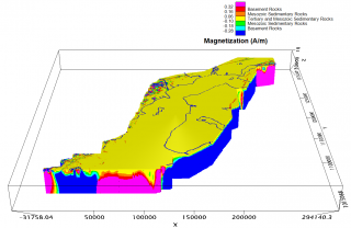
Magnetic Inversion, Cook Inlet
Basin, Alaska
This study was focused on estimating the thickness of
the Mesozoic sedimentary rocks in the Cook Inlet basin. The Mesozoic
section contains the principal oil source rocks within the basin.
Separation filtering was used to isolate the aeromagnetic anomalies
produced by the pre-Tertiary rocks. A 3D magnetic property model was
constructed from 2D inversions along the rows and columns of the
filtered aeromagnetic grid. Well lithologies within the basin were
sampled at the same resolution as the magnetic property model. The
sample statistics were used to develop a color scale predicting the
magnetic lithology of the 3D model.
Jeffrey D. Phillips
jeffp1948@gmail.com
|